CROSS COUNTRY AT EUNGELLA, QUEENSLAND
![]() by Keith Lightbody
by Keith Lightbody ![]()
Mark Facius and I were flying hang gliders while travelling around Australia in September 1979 when we set up our tent in the camp ground at Eungella National Park. At first light we walked along trails on the banks of the Broken River - although there was still some mist we were able to see a number of platypus swimming around in the pools. Using binoculars we were able to watch them diving and surfacing - the water was so clear we could even see them swimming underwater in the early morning sun beams. It was the first time I had watched a platypus in the wild and it made a great start to the day.
"We spent the early morning watching platypus swimming in river pools"
After breakfast we drove to the lookout.
Thermal activity during the morning was intermittent as higher level cloud was
shadowing large areas of the Eungella valley. However by noon about a dozen optimistic
hang glider pilots were set up in the limited space around the lookout - a few
kilometres from where the popular ramp at the Eungella
Chalet was established. Around one o'clock the clouds cleared and sunshine
covered the whole valley. Within fifteen minutes cumulus began forming over
the cane fields and light thermals were rising up the rainforest covered slopes
below takeoff. Wind in the landing area at 900 feet (270 metres) ASL was easterly
at 5-10 knots while in the lookout at 3100 feet (940 metres) ASL it was south-easterly
at 5 knots. I decided to go for it!
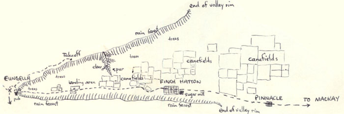
For takeoff the locals had a “gang-plank” perched precariously on the lookout fence. I waited for some wind then after a few quick steps the Jabberwocky was flying in patchy lift in front of takeoff. After flying along the ridge to the right I centred a weak thermal which I slowly worked up to 4600 feet (1400 metres) ASL. Flying along the ridge towards the Eungella pub I found a better thermal which I used to 5100 feet (1550 metres) ASL. Then I turned back towards takeoff in light lift and sink. East of takeoff was all sink along the rim so I headed out towards a large cleared area that was in wind shadow from a spur but had bright sunlight on it. The sink increased at first then changed to smooth lift which I used to climb to 5600 feet (1700 metres) ASL.While circling I had drifted back towards takeoff but I had gained height so I decided to set off for some large ploughed cane fields alongside the road that runs out of the valley towards Mackay. I soon hit a stronger thermal with up to 500 ft/min in the core - I worked it carefully up to cloud base at 6600 feet (2010 metres) ASL.
![]() "Funny Queensland weather - bit different to Western Australia!"
"Funny Queensland weather - bit different to Western Australia!"
![]()
This was my first taste of complex weather patterns while flying. My last thermal was drifting on a 10 knot easterly down low that changed into a 10 knot westerly below the cloud. Cloud base was also 300 feet higher than in other nearby cumulus. The valley was starting to cloud over from the back (west) so I stayed close to cloud base and flew at best speed below a line of cloud towards the town of Finch Hatton. I reached the town with 3100 feet ASL but flew straight past till I found my next thermal about a kilometre along the main road. I was down to 2600 feet ASL and drifting in the easterly wind back towards town so I cored the thermal as quickly and efficiently as possible. At 4000 feet ASL I was almost back to the mill in town but there was now no drift. An eagle joined in 1000 feet below - I watched it closely hoping to find some stronger lift - I wanted to climb quickly as the whole valley from Finch Hatton back to Eungella was now clouded in with a lowering cloud base and heavy dark cloud to the west. Over takeoff I could see some light rain showers. The eagle was not seeking height so I climbed on my own up to cloud base at 5100 feet ASL.
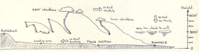
Cloud base had already dropped 1500 feet
in less than an hour. The wind was still westerly at 10 knots up high and easterly
at 10 knots on the ground. However I could now see some clouds to the north
with cloud base about 2000 feet lower still. Smoke in the distance below the
cloud indicated a northerly wind of around 20 knots! Rain clouds now covered
the valley back towards Eungella and they were getting closer to me all the
time. I could now see the next town of Pinnacle so I set a course for there
via some large bare cane fields. I passed some hawks 2000 feet below but they
were not thermalling. The air was getting quite bumpy as the air mass from the
north was moving in quickly. I was unable to find any lift over the cane fields
so resumed my course for Pinnacle. I noticed a cricket match in progress in
the distance - it looked like a good landing spot! Sighting on pine trees near
the cricket oval I reckoned I could make the remaining kilometre so settled
down for a run at best L/D. Westerly winds were still driving along the rain
clouds behind me while I watched the cricket match getting closer. As I set
up my approach around the pine tree play was stopped for tea and the cricketers
started walking off. I hit lift at 100 feet but penetrated through it to land
alongside the cricket pitch at 600 feet ASL. The wind on the ground was a 20
knot northerly. I had flown some 20 kilometres from takeoff and had a taste
of how quickly the tropical Queensland weather can change. Shortly after Mark arrived in the Valiant Charger to continue our journey around Australia.
First published on 7 October 2002. Statistics on usage of this site are gathered by Chilli Tech web stats.
| My
email: |
|